The India-Bangladesh border spans 4,096 kilometers, making it one of the world’s longest international boundaries. It passes through five Indian states: West Bengal, Assam, Meghalaya, Tripura, and Mizoram. The border features rivers, forests, and plains, with extensive fencing to address migration and security. Historical enclaves were resolved through the 2015 Land Boundary Agreement, enhancing cooperation and easing cross-border trade.
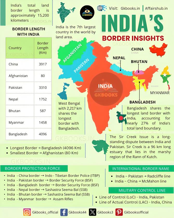
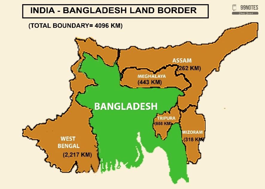
The international boundary between India and Bangladesh is one of the longest land borders in the world, stretching approximately 4,096 kilometers (2,545 miles). It traverses diverse terrains, including rivers, hills, forests, and plains, and is shared by five Indian states:
- West Bengal: 2,217 kilometers
- Assam: 263 kilometers
- Meghalaya: 443 kilometers
- Tripura: 856 kilometers
- Mizoram: 318 kilometers
Features:
- River Borders: Several major rivers, such as the Ganges, Brahmaputra, and Teesta, flow along or across the boundary.
- Enclaves: The border was once known for its numerous enclaves (Chhitmahals), which were resolved through the Land Boundary Agreement (LBA) in 2015.
- Fencing: India has constructed extensive fencing along the border to curb illegal migration, smuggling, and security threats.
- Cross-Border Trade: Several Integrated Check Posts (ICPs), like the one at Petrapole-Benapole, facilitate trade and transit between the two nations.
The India-Bangladesh border, at 4,096 kilometers, is not only one of the longest international borders in the world but also one of the most complex. It is shared between India’s five northeastern states and Bangladesh and runs across a variety of terrains, including rivers, forests, and plains. This border has significant historical, social, and political implications, influencing the dynamics of both countries.
Geography and Terrain
The border stretches through regions with diverse geography, including the Sundarbans mangrove forest along the Bay of Bengal, the Brahmaputra and Ganges river systems, and the hilly terrain of Meghalaya and Mizoram. A substantial portion of the border is marked by major rivers, such as the Teesta, Brahmaputra, and Meghna rivers, which often shift their courses, creating challenges in boundary demarcation.
Historical Significance
The border was largely defined during the British colonial era and then altered after the partition of India in 1947 when East Pakistan (later Bangladesh) was created. The 1971 India-Pakistan War and Bangladesh’s independence further reshaped the border dynamics. The Land Boundary Agreement (LBA) of 2015 was a landmark resolution between India and Bangladesh, solving long-standing issues of border enclaves, also known as Chhitmahals. The agreement led to the exchange of land between the two countries and simplified the border.
Border Fencing and Security
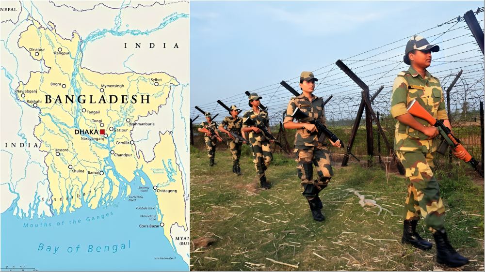
To curb illegal migration, smuggling, and prevent cross-border infiltration, India has constructed extensive border fencing along the majority of the India-Bangladesh border. Security measures include patrolling, surveillance, and watchtowers to monitor activities, especially in sensitive zones like the border with West Bengal.
Border Disputes and Resolution
Disputes over enclaves (small pieces of land belonging to one country but surrounded by the other) were a major issue. The LBA resolved these by exchanging 162 enclaves between the two nations, simplifying governance and citizenship issues. Other unresolved issues, like river management, remain a challenge, as shifting riverbeds can alter the boundary and affect both nations.
Trade and Connectivity
The India-Bangladesh border plays a crucial role in trade and connectivity, with several cross-border trade routes allowing the movement of goods between the two nations. Key border posts like Petrapole-Benapole (West Bengal-Bangladesh), Agartala-Akhaura (Tripura-Bangladesh), and Dawki-Tamabil (Meghalaya-Bangladesh) facilitate smooth exchange of goods and people.
Cross-Border Cooperation
The border is not just a line of separation but also a place for cultural exchange, with both nations sharing similar traditions, language, and heritage, particularly in the Bengali culture. Bilateral cooperation between India and Bangladesh on border management, trade, and water resources has been strengthened in recent years, with regular meetings between border security forces and joint initiatives to curb terrorism and organized crime.
Challenges
The region faces issues related to illegal migration from Bangladesh into India, especially in the states of West Bengal and Assam, where the population density is high. Smuggling, particularly of drugs, cattle, and electronics, is also a persistent challenge. Climate change has increased the vulnerability of the border area, especially in regions like the Sundarbans, which are prone to flooding and shifting riverbanks.
Cultural and Human Impact
Border communities on both sides of India and Bangladesh share close familial and cultural ties, but the border also brings challenges related to identity, migration, and human rights. The division has created barriers for many who have relatives on the other side, with restrictions often causing emotional and economic strain.
In conclusion, the India-Bangladesh border is not only a physical barrier but a significant geopolitical and socio-economic region where cooperation, security, and mutual challenges play out in complex ways. The border’s management continues to evolve, balancing national security concerns with the need for deeper cooperation and understanding between the two nations.


